Wildfire Info 3.0
Free Version
Publisher Description


Wildfire Info - CAL FIRE, InciWeb, MODIS & VIIRS thermal satellite, WFIGS perimeters, CHP & more
Disclaimer: This unofficial app does not represent any government agency and is not affiliated with any government agency. The sources of the data are the publicly accessible sources listed below.
Browse current wildfire and prescribed burn activity throughout all of the world.
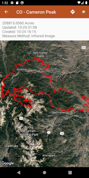
Active Wildfire Perimeter data from WFIGS updated every 20 minutes. Tagged by state, search by name, and filter by acres burned. WFIGS stands for the Wildland Fire Interagency Geospatial Services (WFIGS) Group
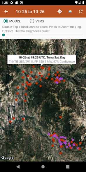
NASA MODIS and VIIRS satellite instruments data: Thermal hotspot maps by region show wildfire activity in the past 48 hours. See hotspot info including fire radiance power, brightness temperature, and confidence.
Air Quality data (PM 2.5, PM10, and Ozone) globally from EPA AirNow and PurpleAir.
InciWeb & CAL FIRE active fire maps: hot-link to the corresponding official incident webpage.
CHP (California Highway Patrol): Incidents in the past 3 hours related to fires are filtered out separately, all traffic incidents are included viewable by last 1 or 3 hours.
Links to current hyper-local weather summary conditions from NWS, NOAA, Government of Canada, and Government of Australia: including temperature, wind and gust conditions, and local forecasts anywhere in the USA, Canada, or Australia at your centered map location.
Wildfire Situation Reports section with mirrored PDFs from NIFC and more.
Pull up the Google Maps app for an area with the embedded deep links.
There is a section for wildfire-related US government Twitter accounts viewable by map by approximate location or sorted into national and state sources in a table view.
Information is posted as soon as it becomes available from WFIGS, NIFC, NASA, InciWeb, CAL FIRE, CHP, NOAA, NWS, Government of Canada, and Government of Australia.
About Wildfire Info
Wildfire Info is a free app for Android published in the Astronomy list of apps, part of Home & Hobby.
The company that develops Wildfire Info is David Gross Apps. The latest version released by its developer is 3.0.
To install Wildfire Info on your Android device, just click the green Continue To App button above to start the installation process. The app is listed on our website since 2022-05-12 and was downloaded 1 times. We have already checked if the download link is safe, however for your own protection we recommend that you scan the downloaded app with your antivirus. Your antivirus may detect the Wildfire Info as malware as malware if the download link to com.davidgrossapps.wildfire is broken.
How to install Wildfire Info on your Android device:
- Click on the Continue To App button on our website. This will redirect you to Google Play.
- Once the Wildfire Info is shown in the Google Play listing of your Android device, you can start its download and installation. Tap on the Install button located below the search bar and to the right of the app icon.
- A pop-up window with the permissions required by Wildfire Info will be shown. Click on Accept to continue the process.
- Wildfire Info will be downloaded onto your device, displaying a progress. Once the download completes, the installation will start and you'll get a notification after the installation is finished.
